

Bluewood Trail Map
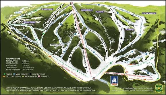
Check out the Bluewood ski resort map above to get a proper feel for the layout before you hit the slopes. The trail map covers 26 runs spread across a vertical drop of around 343 metres, running from 1,728m down to 1,385m. Bluewood is a smaller, independent area that's not linked to any larger ski region, making it a straightforward spot to navigate once you've sussed out the terrain.
Download the Bluewood Trail Map (Image)
Best Runs in Bluewood
-
Catch All (Green): A gentle, wide beginner run perfect for first-timers to build confidence on mellow terrain.
-
Lower Hemlock (Green): A cruisy green trail that winds through the trees with a consistent, forgiving pitch ideal for progressing beginners.
-
Upper Hemlock (Blue): A mellow intermediate run offering smooth grooming and a relaxed gradient for comfortable cruising.
-
Main Street (Blue): The resort's main intermediate artery with consistent pitch and wide grooming that's perfect for carving practice.
-
Silver (Blue): A well-maintained blue run with good width and a steady fall line that suits intermediate skiers looking to rack up vertical.
-
Big Meadow (Blue): An open, spacious intermediate trail offering lovely tree-lined views and enough pitch to keep things interesting.
-
Huckleberry (Black): A steeper run with tighter tree-lined sections that challenges intermediate-to-advanced skiers with variable terrain.
-
West Gully (Black): A legitimately steep black run that tests your technique with sustained pitch and good fall-line skiing.
-
Catch 22 (Black): A challenging advanced run with steep sections and moguls that rewards solid technique and commitment.